-
Location
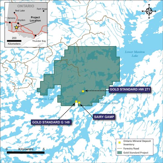
The Gold Standard Project is located in north-western Ontario approximately 65 km north of the city of Fort Frances and within the traditional territory of the Naicatchewenin and Nigigoonsiminikaaning First Nations. The property comprises 284 mineral claims covering 6,016 ha and is accessible by all-season forestry road. The GS project covers three documented high-grade gold showings: GS-HW271, GS- G149 and Sairy Gamp.

-
Highlights
- Three historical showings on the property that represent mine shafts that were active between 1900 and 1903
- Results from recent work by Storm Exploration confirm the high-grade potential Gold Standard and include 166 g/t Au, 88.6 g/t Au and 83.4 g/t Au from grab samples collected at historical workings
- Minimal exploration work completed in the project area. No holes have been drilled near the historical workings and there are only 4 holes on the property with the last completed in 1971
- Accessible year-round
- Low-cost option to earn a 100% interest in claims covering historical high-grade gold workings
-
History
1900 Rainy Lake Mining and Power Co. sank a shaft to 22.8m with 7.4m of cross cuts completed at Sairy Gamp on the shore of Grant Lake 1901-1903 Gold Standard Mining Co. sank two shafts in the area. - One near the shore of Napanee Lake was sunk to a dept of 45.7m with approximately 6m of drifting
- A second shaft was sunk on a peninsula within Neilson Lake to a dept of 28.9 metres with 33.5 metres of crosscutting was done.
1969-1971 The International Nickel Co. of Canada, Limited drilled four exploratory holes totalling 180m approximately 4km northwest of the Gold Standard showings. 1989 Canhorn Mining Corporation optioned the property from R. Fairservice. The company conducted airborne magnetic and electromagnetic surveys and did geological mapping and prospecting. 2004 Temex Resources Corp. carried out mapping, prospecting, channel sampling, and soil sampling. 2011 Neilson Lake Exploration Inc. carried out a magnetic survey, line cutting, and prospecting 2014 Prospectors P. Gehrels and A. Onchulenko complete prospecting and sampling -
Technical Details
The Gold Standard property lies within the Archean Manitou – Stormy Lakes greenstone belt, an 80 kilometre by 20-kilometer assemblage of northeast-trending mafic, intermediate, and felsic metavolcanic rocks, related intrusive rocks and metasediments which have been intruded by Archean granitoid stocks and batholiths. Structurally, the belt is dominated by the northeast-striking Manitou Straits fault (“MSF”). The Gold Standard property is located northwest of the MSF and is underlain by intermediate to mafic volcanic flows and pyroclastic rocks of the Grant Lake group.
Historical work on the property discovered the Gold Standard and Sairy Gamp showings and included shaft sinking on sulphide-bearing quartz veins with historical grades reported to range up to 55.9 git Au. Broadly similar types of gold deposits have been discovered in the area and include the Rainy River deposit (New Gold Inc.) and Hammond Reef (Agnico Eagle).
Work by Storm Exploration in 2022 at the GS HW-271 showing included the collection of rock, soil and bark samples to better understand the style of mineralization and obtain its geochemical signature. Assays from grab samples collected near the GS HW-271 showing returned high-grade results including: 166 g/t Au, 88.6 g/t Au, 83.4 g/t Au and 77.6 g/t Au. Next steps include the completion of a property-wide airborne electromagnetic survey to identify potential drill targets for follow-up.

